Environmental data in rug patterns
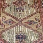
We can read hieroglyphs, but we don´t understand mysterious patterns in oriental rugs. As I was examining the Namescope grid some layouts looked like rug patterns. They also have horizontal-vertical-diagonal paths. Rug tradition is over 2500 years old. It is widely believed that carpet patterns reflect primitive beliefs and rituals. However, already in the sixties, famous carpet expert Joseph McMullan expressed, that the rounded pattern may describe a water basin. That’s true!
My simulations suggest that selected rugs and carpets contain a clever agricultural engineering method. They express how ancient civilizations manipulated soil, water, and vegetation. In rough conditions, they created a wonderful garden type of cultivations. My conference lecture provide more information: 10th-icoc-MLpaper2.5.pdf
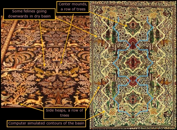
Image 17 illustrates the principle of how I integrated knowledge obtained by computer simulations, rug patterns, and ancient texts. As an output, we can identify the most interesting rugs that may contain relevant layout on the ancient cultivation system. The data could be tested on field experiments. I am looking forward to finding some partners to do it.
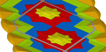
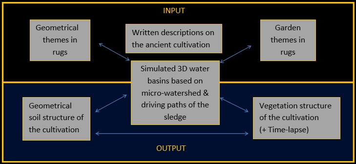 |
| Image 17. Applied principles of rug pattern interpretation |
First I simulated oval octafolia driving paths as in images 18-19. We move soil from the basin to all sides. To make it easier we leave an island and collect some soil on it. So we can get a good planting spot for fruit trees. Using mounds is common practice also nowadays to plant eg. pomegranate tree, especially on heavy soils. The surface irrigated basin provides various moisture and shade levels. In the best cultivation practices, different plants protect each other with minimum competition. As people need various types of plants I expect there might be a hundred good cultivation layouts stored in rugs, plus several hundreds of variations with minor modifications. Evidently the most productive cultivation methods have been developed in the course of centuries through trial and error. Quite naturally the best layouts were marked down (image 21) to transfer the knowledge to the younger generation or to friends and relatives living in the next village. The best cultivation layouts may have been sold at marketplaces and even taken to other countries. This type of cumulated practical traditional knowledge is very valuable even today to find feasible methods for desertification control and for food & fresh groundwater production.
 |
 |
|
| Image 18. Oval oktafolia driving paths | Image 19. Simulated oval oktafolia single basin | Image 20. Oval oktafolia vegetation location map in a rug |
In the course of time, an artistic approach in rugs became prevailing and the meaning of cultivation layouts has been forgotten. Luckily rugs are often made the traditional way in very remote places, so current trends have not necessarily disturbed them. If we made a dendrological survey for rugs and carpets, in a few years we would probably get more valid information than agroforestry researchers can obtain in a generation.
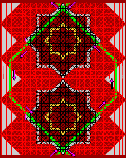
Connecting basin strips
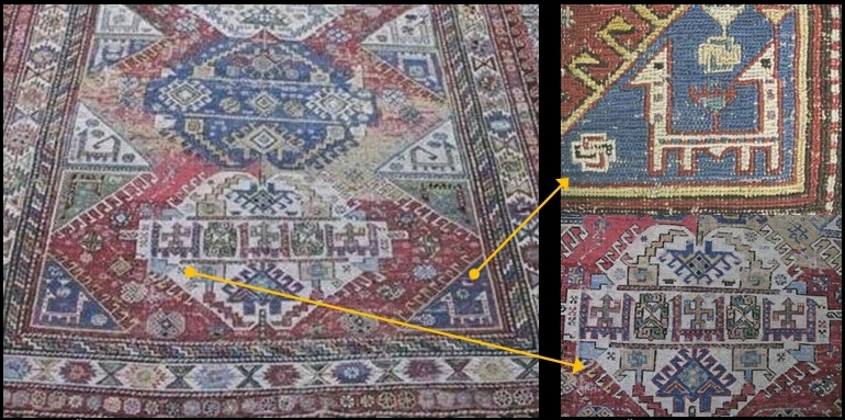
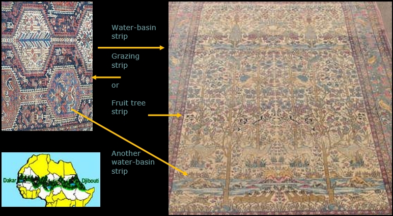
Images 22-30 illustrate the principle of how we can connect individual basins to each other to make basin strips. The driving path is zigzag-8, which moves the soil from the basin bottom to both sides and also into the center mounds. Carpet in image 26 demonstrates some driving paths of the agricultural tool. Observe that the triangles on both sides have serrated edges. It suggests that sledge trails go over them to leave transferred mud over there (compare to image 30).
|
|
 |
 |
| Image 21. Vegetation location map in a rug | Image 22. Computer simulated Zigzag-8 water-basin strip (surface irrigation) | Image 23. Classical geometrical motif in a rug |
 |
 |
 |
| Image 24. Computer simulated water-basin strip full of water | Image 25. Quite a similar basin strip in a carpet | Image 26. Some driving paths of the sledge, compare to images 28, 30 |
Images 22-25 demonstrate raising water. Water will infiltrate into the soil in a few days.
In image 28 sledge dragging animals and drivers are at work.
| Making water-basin strips | Image 27. Detail on dragging animals |
 |
|
| Image 28. Moving mud with an animal draught agricultural tool | Image 29. Sledge driving people at work |
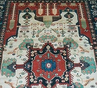
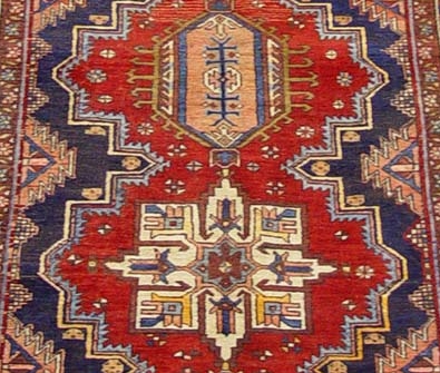
Comparing simulation to rug layouts
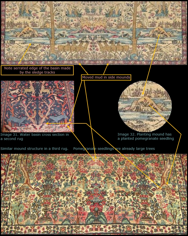
Kerman Ravar pictorial rugs are often made according to ancient miniature paintings. Quite often they hold photograph types of images from the ancient scenes. If we compare these scenes to geometrical rugs and to simulation models, we can make some interesting observations. Systematic terrain microtopography and water elements suggest rational man-made cultivation. Place and shape of soil mounds agree with the theoretical computer simulation. By using these we can identify selected rugs to interpret how the system worked and build time series describing how a surface irrigated young cultivation proceeds from young stands to aged fruit tree gardens. Image 30 shows the starting point. The artificially made basins are quite new, since:
- Mounds surrounded by water are still very steady
- Basin shoreline still has a serrated edge made by the animal-drawn agricultural tool
- There are just planted young pomegranate seedlings on mounds
| Image 30. Ancient water basin in a Kerman Ravar rug | (Click to enlarge 31.) |
 |
|
| Image 33. A longitudinal section in another rug | |
| Image 34. A pomegranate tree grows in a planting mound in connection with a water basin. | |
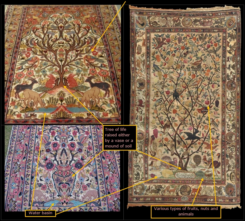 |
|
| Image 35. A pomegranate tree grows in a vase in connection with a water basin. | Image 36. A tree with various types of fruits in a planting mound in connection with the water basin. |
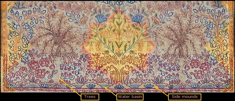
A few decades later, the cultivation will look like in images 33-39. In image 38 the computer model has been placed over the rug. We can conclude that: –
- The islands fit exactly to the rug layout
- Trees are surrounding the islands and their roots can exploit the irrigated zone
- A planted row of trees/bushes covers the side banks.
- The fruits/berries/seeds of the trees attract rabbits, antelopes, birds, etc followed by hunting animals.
- Some lions are going downwards to the basin area –
- Other lions are resting and enjoying the shade under the trees around the island. The backbones of the cats are towards nicely warm mounds.
 |
|
| Image 37. A garden rug with a ’3D’ view | Image 38. Quite similar garden rug, with the simulation layout |
In image 38 computer simulation model is placed over a garden rug. Vegetation layout seems to be very rational. In my view, this entity would be a good starting point for practical field tests.
 |
| Image 39. Water basin and its vegetation in a side view. |
In 39 image observe abundant multilayer vegetation coverage, mounds, and water basin.
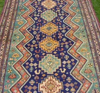
| Image 40. Basin strips in a rug | |
 |
|
| Image 41. Great Green Wall logo | Image 42. The same rug as in image 30 |
My motive to make the Namescope game is my concern about environmental degradation. Especially Africa and parts of the Middle East suffer from desertification, food and water shortage, unemployment. My aim is to reintroduce some vanished environment technologies to tackle these problems with simple tools, that are available also for poor people.
At the moment Europe is facing a severe refugee problem. There is an urgent need to create job opportunities for people in North-Africa and Near East. By applying these ancient agroforestry cultivation methods we can provide a livelihood for millions of people in their homelands. We can turn wastelands and ruins of wars into productive fruit gardens!
United Nations, African Union, and the European Union are considering the “Great Green Wall Project”. The aim is to control the expanding Sahara desert and moderate climate change. The task is gigantic and very complicated to accomplish with modern methods. Ancient methods do not require sophisticated infrastructure and huge investments. Local people can establish expanding green spots to produce food and water for their families. Vast areas also in India and China are suffering fresh groundwater scarcity and desertification. In India, it has been presented a plan to plant 5 billion jatropha plants to produce biodiesel fuel. The plant requires 600mm rainfall/year. This means, that the project may decrease field areas for agricultural crops, which may cause food shortages. The ancient method may require 300-450 mm rainfall/year, so plants could be established on wastelands. As a byproduct, we may also get more food, groundwater, and desertification control.
 |
| Kuva 43. People taking care of young multi-cropping cultivation. Various animals. Note person in front sits under a tree that grows on a heap. |
| Next article: Back Home, Namescope – free oracle seal maker online |
 |